Author Archives: Admin

Through the Prince Christian Sound

Photos by Carolina Nobre

“Greenland is great because it has complex boundary currents,” explains Bob Pickart. That’s why, in the course of our trip, we’ve spent a lot of time hanging out around  Greenland: to study the currents that snake around the sloping ocean floor near it. Scientists on board the Knorr are accomplishing this with round-the-clock deployments of various instruments.

But Greenland is also great because it is very scenic. After days of hovering to the east of Greenland, the science crew took the day off as we steamed through the Prince Christian Sound.

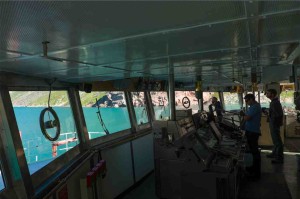
bridge

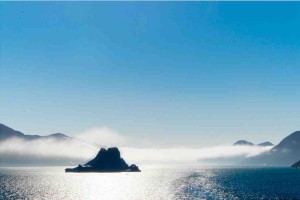
misty_iceberg

A narrow channel called the Prince Christian Sound splits the very southern bit of Greenland from the rest of the remote land mass. For most of the year, it is clogged with pack ice. For now, its clear —save for icebergs, and little chunks of ice called “growlers” — allowing water, and a few ships, to flow through. The water in this channel is a mere trickle compared to the North Atlantic, so we’re not here to study it, just to use it as a throughway. (It would be an equally long trip to travel around the tip of the country.) 

Continue reading

Deploying tripods on the continental shelf

Dan explains the tk to CTD watch stander Shannon Rauch

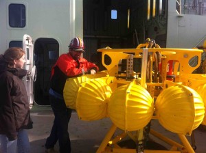
WHOI scientist Daniel Torres explains the instruments on board the tripod to CTD watch stander Shannon Rauch.

The so-called “tripods” on board the Knorr look like lunar landers, or blobs of giant pollen, depending on how you tilt your head. They’re a kind of mooring: a package of instruments that sits on the ocean floor, measuring the water above and around it.

Deploying moorings, is the primary point of our trip. Tripods are moorings that go in shallow water — about 200 m. A weight in the middle of the tripod sinks the thing to the bottom of the ocean.

In two years, when Bob Pickart and his team return to this spot, a sound signal will release the tripod from the weight; those yellow floats will carry it up to the surface. Hopefully, they’ll be packed with data. 

TKTKTKTK

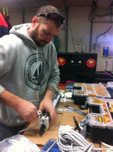
Brian Hogue prepares attaches a CTD to the rope that will float above the tripod

The Payload

An instrument called an Acoustic Doppler Current Profiler (ADCP) sends up sound signals to measure the velocity of currents flowing above it. Sound signals go out at a particular frequency, bounce off the zooplankton and other particles that travel along with the current, and then return to the ACDP back at a different frequency depending on the speed of the flow. This is called the doppler effect; it is the same concept that makes radar guns that police use to catch speeding drivers. From ADCP data, scientists will know how fast the water in the ocean above the tripod is moving. 

Every 15 minutes, the CTDs — one attached to the tripod, and one attached to the string above it — will collect conductivity (used to determine how salty the water is), temperature, and density data. They’ll take these stats every 15 minutes — in contrast to the 32 measurements per second that the CTDs deployed on the rosette take. But these mooring order viagra australia measurements happen over two years, providing a record of what happens over the course of several seasons. 

Continue reading

Resolutions

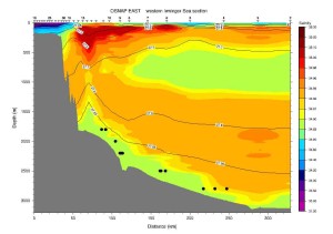
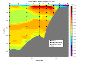
At all hours of the day and night, the team of 6 watchstanders have been taking turns hauling a heavy piece of equipment into and out of the ocean. The Knorr stops, and the watchstanders on duty go through an elaborate ritual of deploying a “CTD rosette.” The instrument collects data on the water as it descends and then ascends — sometimes 3 kilometres deep. It is a process that can take hours. When it’s done, the Knorr moves to the next designated spot in the line of CTD stops, and the whole thing starts over again. Three days of that — 21 stops — provides a snapshot of a section of the ocean that looks like this: Data from three days of CTD

The varying color shows the varying salinity of the water. That purple color depicts fresh, cold, Arctic water, melted from icepacks North of us — with contributions from more local glaciers. The bright red: warm, salty, water, traveling up from the subtropics via the gulf-stream. Lower down, in green and yellow, is a third current. All this water is making its way around the tip of Greenland as “boundary currents” at the moment. It’s headed North West for a bit before they take a turn and go South. 

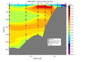
The CTD data is collected in between stops to place buy phentermine online moorings — long strings of instruments, shown in these pictures as lines and dots. These will take a snapshot of the water every two hours, and only take data where instruments (dots) have been placed.  In contrast, the CTD rosette collects data every few meters as the rosette makes its descent, collecting information along lots of points — which makes for a spatially high-resolution picture of the water.

To get an idea of what a mooring snapshot will look like, Bob Pickart modified the snapshot provided by the CTD rosette, making a map using only measurements that were taken approximately where the mooring instruments will be. That modified map, with reduced resolution, looks like this:

That data translated into what a mooring would see

That the picture provided by the “moorings” captures the important contours of the CTD rosette data is encouraging. “You see something like this and you can’t help but get very excited,” says Pickart. 

So, why use moorings at all?

Continue reading

How do we measure currents?

By Nick Foukal

As our chief scientist Bob Pickart says, we’re out here on the ocean to build a “picket fence.” Practically though, the pickets in this fence – moorings – are needle-thin on the scale of the ocean. We only have about 40 “needles” (deployed by this leg of OSNAP and others) to span the entire North Atlantic and the flow we’re measuring is about 15 times stronger than all the rivers in the world combined. This is a tall task, so how do we do it?

Nick Foukal at work at the CTD watch station.

Nick Foukal at work at the CTD watch station.

The key is the ocean’s density, which is a function of the water’s temperature, salinity and pressure (pressure increases as one goes deeper). As luck would have it, many of the instruments we are deploying on this cruise measure those three variables. And from those data we can construct a map of density across the OSNAP line. 

For the most part, the densest water in the ocean is near the bottom. Heavy things sink: that much is fairly intuitive. But there are also areas where the density contours (also called isopycnals) are sloped, and these are locations where the flow tends to be strongest. Dense water wants to flow under less dense water, but due to the rotation of our Earth – we’re looking at a huge distance, almost 10% of the circumference of the planet – instead of that dense water flowing toward the less dense water, it often flows 90° to the right of where it should (in the southern hemisphere the water flows 90° to the left). This is what oceanographers call ‘geostrophic flow’, and most of the ocean obeys the rules of geostrophic flow (areas that don’t always obey geostrophy include coastal regions, the bottom and the very surface). It’s like attempting to push someone overboard and the person ending up on the deck next to you – not exactly intuitive. If that’s hard to understand, you’re not alone: as I enter my fourth year of graduate school in oceanography, I’m still trying to come to grips with this phenomenon… that is the geostrophy one, not the man overboard experiment – I’m pretty sure I know how that one would end up. 

Continue reading

Night watch by the light of the supermoon

The Knorr never sleeps. So neither do the scientists on it — or at least not all at the same time. Between sunrise and sunset, two “watch standers” and one marine tech are engaged in a data-collection all-nighter.

Sunday was the fifth night shift of our cruise, the night of the full, close-to-Earth moon, and the night that I chose to sit in. Close to Greenland, we were cruising over the continental shelf: the water is a little shallower here, the currents more interesting, and the work of the watch standers faster-paced.
CTD

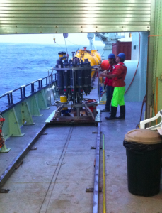
Preparing to drop the rosette into the ocean at the beginning of the night.

The primary job of the watch standers is to usher a heavy and expensive instrument — called a CTD rosette, for its shape — to the bottom of the ocean. When watch standers Robert Daniels and Mironov Illarion take over at 8 PM, the thing is about 1,000 meters underwater, and rising at 60 meters/minute. Every couple hundred meters it stops, they hit a button that says “fire bottle” on the screen, and it closes one of its grey tubes to add 10 liters of ocean water to its load. Then one of them will press “talk” on a  speaker box and tell an operator to bring the rosette up to a new height. Along its journey, sensors on the rosette measure the salinity, temperature, and density of the water: the “fingerprint” of a current. A lab tech, Elizabeth Bonk, will analyze the salt samples collected by the bottles.

This procedure — a CTD cast — is a staple of oceanography. Illarion and Daniels have both done the casts before — Illarion in the Arctic, and Daniels off the Bering straight. The CTD data they collect here will contribute to a high-resolution snapshot of what the current around Greenland is doing.

Creating this snapshot is, for now, an act of construction work. Illarion and Daniels have showed up to work in steel-toe boots; they add hard hats and orange life-vests to their safety ensemble. (Illarion is also wearing neon yellow overalls, his own sartorial contribution to the “safety” look.) When the rosette returns to the surface, we go outside, and stand on the deck. It is 50 degrees, plus wind chill. Nicholas Matthews, the marine tech on duty tells me to stand inside the garage or put on a hard hat — so he doesn’t get in trouble.

The rosette, on its wire line, emerges from the water. The watch standers hook the metal frame of the rosette with poles longer than they are tall. From a control room above, an operator recoils the wire, and retracts the metal beam that it is hooked on so the rosette swings onto the deck of the boat, and lowers onto a little wooden platform. The watch standers strap it in, and then, with the pull of a lever, the platform moves the rosette from the deck into a little garage, where I am standing. Beneath the light of a heat lamp, Illarion sprays the frame down with a fresh water hose. He and Daniels collect salt samples from each of the six bottles that they fired during the cast.

We go back inside, and then, maybe half an hour buy lasix online later return to the deck-garage to do the reverse: the watch standers move the rosette onto the deck, unstrap it, and the operator lifts it into the ocean. From the control room, we wait for this piece of machinery — which, for all the world, looks like Iron Man’s heart or a slice of a particle collider — to make its way to the bottom of the sea.

Continue reading

Here we are, headed toward Greenland

In my old bedroom at my parents’ there is a framed cloth with my name and birthday embroidered in thread. Around the border, there are ducks. They are floating on a blue, cartoon-style wave.

Susan Lozier made it for me when I was born. Now, she’s sending me to sea.

How long 'til living on this ship feels Knorr-mal?

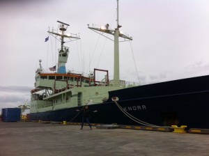
Here’s the RV Knorr, parked in Reykjavik

In case you’re new here (like me): Lozier is an oceanographer at Duke, and one of the scientists leading OSNAP. The acronym stands for Overturning in the Subpolar North Atlantic Program.  The “overturning” refers to a sort of conveyor belt of water:  the sun warms water at the equator, some of it flows north past Iceland where it drops off its heat, sinks, cools, and then makes its way south. (See the arrows in OSNAP’s cartoon logo? That’s the general idea). This Atlantic heat-shuttling keeps Europe on the whole cozier than it would be if it were sitting its own stagnant bath tub, instead of the same body of water as the rest of the whole wide world. And, of course, human-cause climate change will alter this process — though scientists are not certain of exactly how.

 So, starting this summer OSNAP — a multi-country endeavor, over a decade in the making — is setting up what oceanographer Bob Pickart calls “a giant picket fence” across the ocean. This — a collection of stationary instruments, floats, and gliders — will be  a check point across the North Atlantic for water as it makes its way north, and then south.  Pickart, who works at Woods Hole Oceanographic Instituition, is another leader of OSNAP’s US arm — and importantly, he is the lead scientist on the R/V Knorr for the month of August (Lozier is spending the summer on land at Duke).

We are on this boat for a month to deploy Pickart’s section of the fence: 8 strings of instruments up to 3 kilometers deep, that will be weighted to the ocean floor. These are called “moorings,” and their purpose is to track the underwater highways of flowing water. Each mooring, with its heavy hardware and smart gadgets, has a $200,000 price tag. We’ll be carefully placing them near the southern tip of  Greenland, where they will spend two years alone, collecting data, which Pickart and a new team will retrieve in 2016. On our journey to drop off the moorings, we’ll also make 50 pit stops to take quick stats on the ocean at various depths. These pit stops will happen whenever we arrive at a designated pit-stop location — so we’ll be throwing sensors into the ocean at all hours of the day and night.

Well, Pickart and an assortment of students are here to do all that. I’m here to observe.

For my part, I grew up to be a writer. I’m based out of my office (a corner of my living room) in Philadelphia, where I write and fact check for magazines and websites. I’m a freelancer, which means I can temporarily re-locate wherever I please. The OSNAP grant is comping my room and board for a month, in exchange for the open-ended challenge of conveying the project to the greater world via this here blog.

Continue reading