OSNAP data policy
Data from the OSNAP moorings, gliders and floats will be made publicly available no later than two years after the data are collected. Please refer to the OSNAP data management plan for more details regarding the OSNAP data policy and management plan. Before the use and publication of any OSNAP data, users are strongly encouraged to read the full OSNAP data policy. We draw your attention to the following excerpts from that policy:
- Any person making use of OSNAP observational data and/or numerical results must communicate with the responsible investigators at the start of the analysis and anticipate that the data collectors will be co-authors of published results.
- In cases where investigators choose not to be co-authors on publications that rely on their data, the parties responsible for collecting the data and the sponsoring funding agencies should be acknowledged, including reference to any relevant publications by the originating authors describing the data sets and a reference to the data set itself using its DOI.
- OSNAP data are intended for scholarly use by the academic and scientific community, with the express understanding that any such use will properly acknowledge the originating investigator.
How to acknowledge data from the OSNAP project:
OSNAP data were collected and made freely available by the OSNAP (Overturning in the Subpolar North Atlantic Program) project and all the national programs that contribute to it (www.o-snap.org).
Digital Object Identifier (DOI) for the 2014-2022 data:
The full DOI for this data set: https://doi.org/10.35090/gatech/78023
How to cite the 2014-2022 data in journals:
Fu, Y., Lozier, M. S., Bower, A., Burmeister, K., Carrilho Biló, T., Cyr, F., et al. (2025). Characterizing the interannual variability of North Atlantic subpolar overturning. Geophysical Research Letters, 52, e2025GL114672. https://doi.org/10.1029/2025GL114672
Digital Object Identifier (DOI) for the 2014-2020 data:
The full DOI for this data set: https://doi.org/10.35090/gatech/70342
How to cite the 2014-2020 data in journals:
Fu, Y., Lozier, M.S., Biló, T.C. et al. Seasonality of the Meridional Overturning Circulation in the subpolar North Atlantic. Commun Earth Environ 4, 181 (2023). https://doi.org/10.1038/s43247-023-00848-9
OSNAP time series
Please fill out the form below before downloading our 6-year datasets. If you wish to receive notification about OSNAP data updates, please fill in your email (optional).
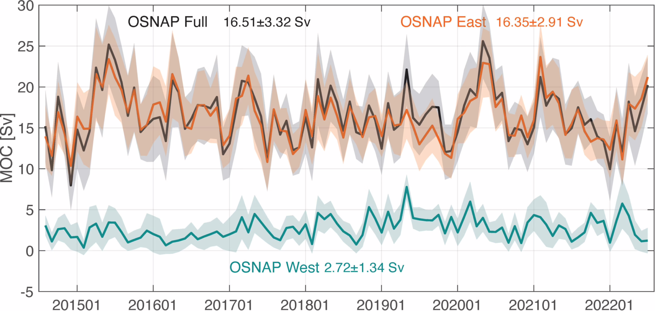
The monthly MOC, MHT, and MFT for 2014-2022, along with the streamfunctions across the full array, the OSNAP West and East subsections, respectively, as well as gridded temperature, salinity, and velocity fields are made available and can be downloaded here. Please contact Yao Fu for more details about the 8-year OSNAP data (yaofu@usf.edu).
The OSNAP data for the 2014-2018 period can be downloaded in the following links
MOC, MHT and MFT, Gridded potential temperature, salinity and velocity fields.
Instrument data
Calibrated and quality-controlled data from moored instruments and gliders were generated and made freely available by each participating group.
Mooring data
- Canadian Shelfbreak Array
- German 53ºN Array
- US Labrador Sea Eastern Boundary Array
- US East Cape Farewell Slope Array
- UK/US Deep Western Boundary Current Array (Irminger Sea)
- NIOZ Western Mid-Atlantic-Ridge Array
- US Eastern Mid-Atlantic-Ridge Array
- UK Iceland Basin Array
- UK Eastern Boundary Current Array (Rockall Trough)
Glider data
Float data
CTD section data
2014
2015
- OSNAP 09 (64PE400)
2016
2018
2020
2022
- OSNAP 31 (M184)
2024
- OSNAP 35 (MSM128/2)