By Susan Lozier
Though thousands of miles from the Labrador, Irminger and Iceland seas, where all the OSNAP action is taking place this summer, I can almost feel seasick at times reading the emails from my students and colleagues at sea. Admittedly, the chances of actually getting seasick in the comfort of my office here at Duke University are slim, so this summer I can only experience that ‘pleasure’ vicariously.
OSNAP – which stands for Overturning in the Subpolar North Atlantic Program – is a large international program designed to measure and understand the overturning circulation in the subpolar region of the North Atlantic. The overturning circulation involves the northward flow of upper ocean waters from the tropics to the polar regions and the southward, return flow of deep waters. Since the upper ocean waters are warm relative to the deeper waters, this flow pattern (poleward in the upper branch and equatorward in the lower branch) results in a movement of heat from the tropical to the polar regions. And this is why people other than physical oceanographers care about the overturning circulation: it moves heat around. And this heat redistribution impacts regional and global climate, such as rainfall and atmospheric temperatures. Just like most everything else about the ocean, the overturning circulation is variable, meaning that it changes with time. But we don’t know how large or how rapid those changes will be in the years ahead and we really don’t know what creates those changes. So, since we are quite interested in understanding how this ocean circulation will impact climate in the years and decades ahead, we have launched this new program to deploy an observing system in the subpolar North Atlantic to measure the overturning circulation. You can learn more about our program at the site www.o-snap.org.
Here is what is happening this summer:
The first OSNAP cruise started in early June aboard the RRS James Clark Ross. Filled with UK scientists led by Penny Holliday and Brian King, the seven-week (!) cruise trek runs from St. Johns, Newfoundland, Canada, across the Labrador Sea to the southwest of Greenland, around Cape Farewell and then across the Irminger Sea, the Iceland Basin, and the Rockall Trough, ending their measurements off the western coast of Scotland. Whew! The crew has maintained a fabulous blog of their journey, complete with not-to-be-missed photos. Check it out here: http://ukosnap.wordpress.com/
The second OSNAP cruise was aboard the U.S. vessel, the R/V Knorr. The Knorr left the dock at Woods Hole Oceanographic Institution on June 19th, headed to the Newfoundland basin to deploy sound sources and RAFOS floats. I was fortunate to be in Woods Hole to see the ship and Brian Guest, chief scientist, on their way. We already have some good news based on Brian’s work on that cruise. On July 6th two test floats popped up on schedule and let us know that all 3 sound sources that Brian deployed are working. Three down and seven to go!
Canadian scientists aboard the CCGS Hudson, led by Blair Greenan, left Bedford Institute of Oceanography on June 30th and as part of their work deployed three moorings along the Labrador slope at 53°N. These three moorings are the westernmost moorings for the OSNAP West line.
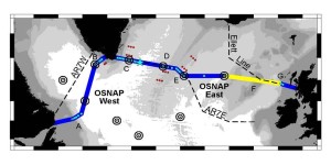
And just this past Sunday, 7/6/14, another OSNAP cruise got underway. US, UK and Dutch scientists boarded the R/V Knorr in Reykjavik, Iceland. Led by Bill Johns from the University of Miami, these scientists will be busy deploying moorings, sound sources and floats along what we call the OSNAP East line. See the schematic below, showing the OSNAP lines across the subpolar North Atlantic.

Canadian shelfbreak array; (B) US West Greenland boundary array; (C) US/UK East Greenland boundary array; (D) Netherlands western Mid-Atlantic Ridge array; (E) US eastern Mid-Atlantic Ridge array; (F) UK glider survey over the Hatton-Rockall Bank and Rockall Trough; (G) UK Scottish Slope current array. Red dots: US float launch sites. Blue star: US OOI Irminger Sea global node. Black concentric circles: US sound sources.
Finally, in early August, the scientists on the third KNORR OSNAP cruise will head back to Reykjavik to disembark and make room for the U.S. scientists occupying the fourth cruise, also on the Knorr. Led by Bob Pickart, Woods Hole Oceanographic Institution, these scientists will deploy moorings, sound sources and floats along the OSNAP West line.
When all is said and done, a fair number of instruments will have been placed in the water to measure the currents and their temperature and salinity. Though we have about two years to wait until we get the first numbers back, many OSNAP scientists will be busy working with other observational data, and also modeling data, to help set the context for our new observations when the data does start rolling in. Of course, someone has to go back out and retrieve those instruments and deploy new ones after two years. Maybe then I will get my chance for some real seasickness.
[portfolio_slideshow id=271]
Pingback: Here we are, headed toward Greenland | OSNAP