by Sijia Zou
In the past a few months, I have been working on identifying the spreading pathways of Iceland Scotland Overflow Water (ISOW) in the eastern North Atlantic, with focus on its southward spreading along the eastern flank of the Mid-Atlantic Ridge (MAR).
The ISOW is formed in the Nordic Seas and overflows into the Iceland basin over the sill between Iceland and Scotland. Together with the Denmark Strait Overflow Water (DSOW) that overflows via the sill in Denmark Strait, and the Labrador Sea Water (LSW) formed in the Labrador Sea, these deep waters make up the lower limb of the Atlantic Meridional Overturning Circulation (AMOC). An understanding of the spreading pathways of these deep water masses is fundamental to our understanding of AMOC structure.
Traditionally, the Deep Western Boundary Current (DWBC) was considered the major conduit from the subpolar to the subtropical gyre for these deep water masses: ISOW travels cyclonically in the Iceland basin within the DWBC, enters the western subpolar gyre via the Charlie-Gibbs Fracture Zone (CGFZ) (see Figure 1, solid blue curve) and joins the DSOW and LSW in the DWBC in the western basin.
However, recent studies question the DWBC’s representativeness of the lower limb of the AMOC. In the western North Atlantic, where all the three deep water masses are present, Lagrangian floats and model simulations reveal interior pathways of the deep waters from the subpolar gyre to the subtropical gyre (Bower et al., 2009; Gary et al., 2012; Lozier et al., 2013; Gary et al., 2011; Lavender et al., 2005; Xu et al., 2015). In the eastern North Atlantic, where ISOW is the primary deep water, two other ISOW pathways are identified (see Figure 1, dashed red curves): one crosses gaps in the Reykjanes Ridge (RR) north of the CGFZ (Xu et al., 2010; Chang et al., 2009), and the other flows southward along the eastern flank of the MAR into the Western European Basin (Xu et al., 2010; Lankhorst and Zenk, 2006). These two pathways are less well studied or observed.
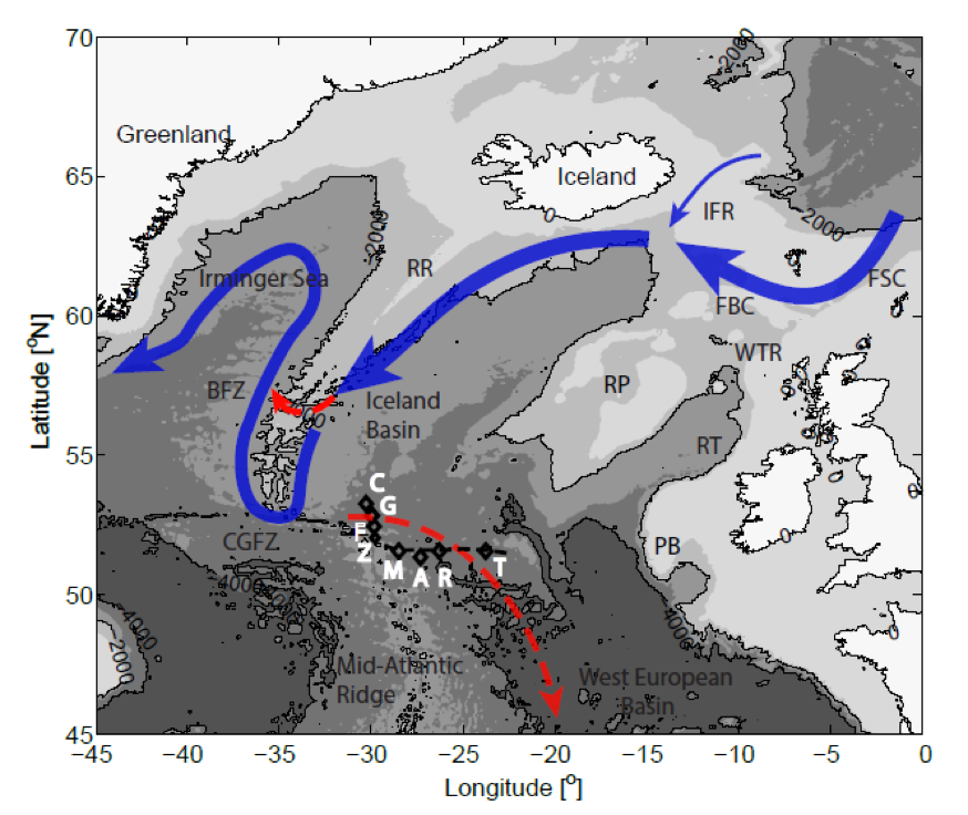
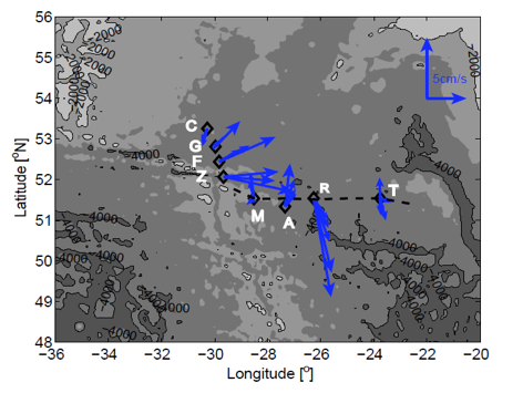
To study the southward spreading of the ISOW east of the MAR, I have been using previously unpublished current meter data east of the CGFZ from Dr. Walter Zenk at GEOMAR in Germany. The moorings C, G, F, Z, M, A, R and T (labeled in white in Figure 1), were deployed between 1998 and 1999 and stayed in water for 1 year.
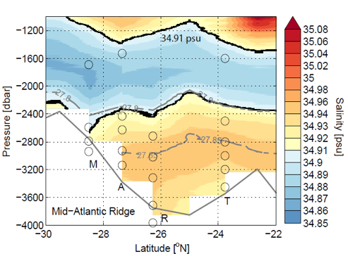
Figure 2 (left) shows the mean velocity at mooring locations at current meter depths between 1650 and 3890m. The deep-reaching northeastward North Atlantic Current is observed at moorings G, F and Z. A bottom-intensified southward flow is observed at mooring R, with a maximum southward velocity 8 cm/s measured by the bottom current meter at 3967 dbar. This strong southward spreading is in the salty ISOW layer, as shown in the hydrographic section from the CTD section (Figure 2, right) in June 1999, when moorings M, A, R and T were recovered. A similar southward spreading of deep waters in the ISOW layer is seen from the velocity fields in a high resolution model (1/12°) FLAME, with overall weaker magnitude and strong interannual variability (not shown).
A manuscript with these results is in preparation. In the manuscript, detailed analysis of this southward branch is conducted, including the spreading from a Lagrangian perspective, the origin of the south-flowing deep waters and a quantification of different branches of ISOW pathways in the eastern North Atlantic. In addition, the RAFOS floats released east of the RR at ISOW depths during the OSNAP cruise in the summer of 2014 will provide further evidence of the various spreading of ISOW.
This analysis work is completed with my advisor Susan Lozier, Walter Zenk, Bill Johns from University of Miami and Amy Bower from WHOI.