By Amy Bower and Heather Furey
During the summer of 2014, the first setting of 40 deep acoustically-tracked RAFOS floats was made along the OSNAP line (see Mysteries of the Deep Subpolar North Atlantic). Most of these floats were programmed in advance to stay submerged for two years, all the time drifting passively with the deep currents. However, a few floats were programmed for only 180 days so that we could determine how the sound sources are working and how well we were able to adjust the floats’ weight so that they drift just about 100-200 m above the sea floor. Believe it or not, a half year has already passed since the floats were deployed, and the three scheduled to surface after that time have done so over the past few months.
The data collected by these floats indicate that the sound sources all seem to be working properly. The floats were not able to hear the sound sources continuously because of the extremely rough topography of the Reykjanes Ridge, the submarine mountain range that extends southwestward from Iceland forming part of the mid-Atlantic ridge system. Sometimes the floats drift behind underwater mountains that prevent the acoustic signals emitted by the sound sources from reaching the float. This can lead to a short gap in our knowledge of where the float was during that time. This is completely expected and we can usually interpolate the float position during the time it is “invisible”.
The trajectory of one of these first three floats is illustrated in Figure 1, superimposed on the bathymetry of the Reykjanes Ridge. This float was released in the Charlie-Gibbs Fracture Zone (i.e., not on the OSNAP line) during the transit of the R/V Knorr from Woods Hole to Iceland. It was ballasted to sink to 2200 meters and drift with one of the dense overflow water masses, specifically Iceland-Scotland Overflow Water, which contributes to the lower limb of the Atlantic Meridional Overturning Circulation. We want to determine the pathway of this water mass after it crosses the Mid-Atlantic Ridge.
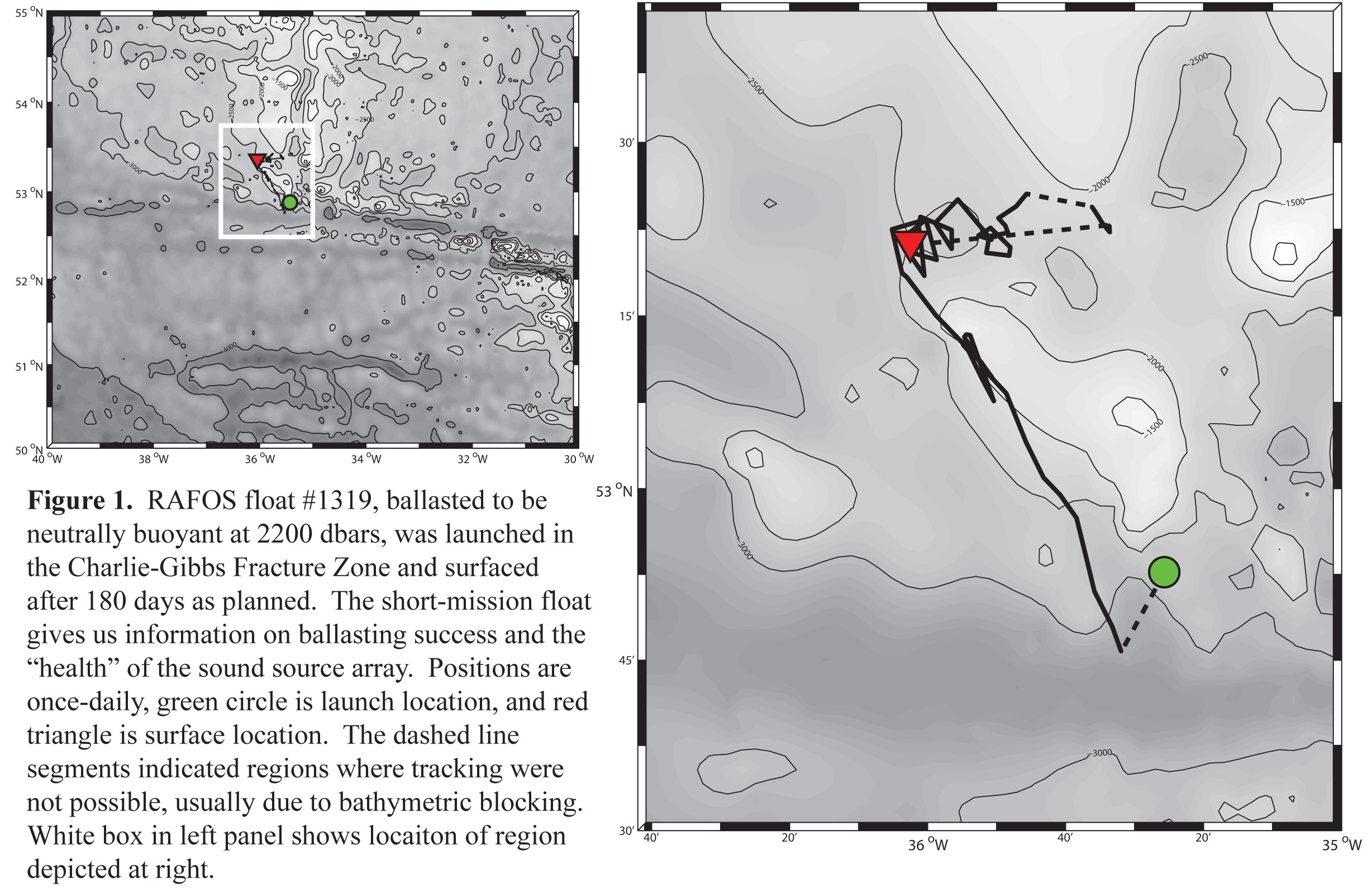
In the left panel, the float trajectory is shown on a large map of the region for context. From this we can see that the float drifted quite quickly northward paralleling the crest of the Reykjanes Ridge. This is one of the two pathways we anticipated, the other being westward from the launch position. The most interesting aspect of this trajectory is however evident in the right panel, which shows a zoomed-in view of the trajectory. About 25 days after the float was launched, the float started looping in the lee of a high point along the ridge crest. The clockwise looping continued for about 30 days with a looping period of 5 days. This is clear evidence of the formation of a small eddy (with looping diameter of about 10 km) along the path of the Iceland-Scotland Overflow water mass, and is a reminder of how turbulent these currents can be.
What happened next is one of the risks of working so close to the sea floor with floats. This float drifted eastward into the rift valley of the Reykjanes Ridge, which is surrounded by many high submarine peaks. Once inside, it was very difficult for the acoustic signals to reach the float and thus our ability to track it becomes very sketchy. From the float’s depth data (not shown), we determined that this float eventually hit one of these high peaks—not hard—but with enough contact to pick up some sticky mud or sediment. With this albeit tiny additional weight, the float sank somewhat below the water mass of interest. After 180 days underwater, it dropped its ballast weight, rose to the surface and transmitted all its data. It apparently never made it out of the bathymetric “trap”. This development has prompted us to modify the next set of 40 floats so that they will be less likely to hit the bottom at all, and if they do, less likely to pick up sediment.
This is pretty much the last we will hear from the deep OSNAP floats for the next 18 months, until the rest of the first setting from Summer 2014 surface in Summer 2016. This type of research is akin to a long space mission, where we have to wait a long time to get the results that will help us understand how the oceans work and how they might be changing.