OSNAP, Year 3 Leg 1, 56 42.45N 33 42.02W, 19-July-2016, At the Bight, and Oceanographer Heartbreak.
by Heather Furey
So, we made it! We are at the Bight. I have to say though, troops are restless. There are 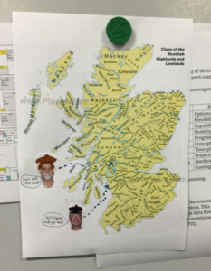 rumors flying around the ship about when we’ll get back. I have heard, ‘Not til Saturday 0600’, ‘Definitely Friday 2200, before the bars close’, and ‘Friday morning 0900’, as time estimates. All ETAs reported just today, and all from reputable sources! We are in the UNOLS ship schedule to hit the dock Saturday July 23rd, so anything earlier is, well, earlier. Really, it just depends how fast we can get this set of nine CTD stations done. There is a lot of motivation to get back Friday night. We are in the middle of the third CTD cast as I write.
I saw the first sun I have seen in a long time this morning as we travelled south, though it is cold outside today. The ocean looks pretty much the same here as anywhere else, but underneath us is a totally different story. We are over the south channel of the Bight now, a deep channel running east to west through the Reykjanes Ridge. Here and the north channel of this fracture zone are the only deep passages from east to west through this mountain range for hundreds of kilometers to the south, and the very first passage through since the deep overflow current first formed and started flowing southward at the head of the Iceland Basin.
From the perspective of being at the south channel’s deepest point, the mountains rise 1200 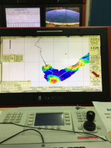 meters to the south and at least 1400 meters to the north. We have not passed over the highest point yet, so I have no multi-beam bathymetry data to know how shallow the northern mountain stands. If I were out hiking, I would expect some strong mountain pass winds through such a gap due to orographic steering. We think we might expect this here too in an oceanographic sense, water flowing strongly from east to west, funneled through this narrow gap. A velocity profile will be available soon, once ‘the package’ is on deck. (‘The package’ is the suite of water sample bottles, LADCP, which measures velocity, and CTD, which measures pressure, temperature and salinity.)
There are a couple of moorings out here now, one in each channel, that get pulled out summer of 2017, next year. Can’t wait to see what those data show, but they are so much more valuable for the velocity, temperature, and salinity data were collecting right now. We are taking a reference section, from which we can get transport, and to which we may compare the two years of mooring velocity, temperature and salinity data later.
Back in the lab, though, folks are packing up. Clean work tables? Packed bags four days  before we hit port? Definitely, folks are ready to go home. And getting creative with how they spend their spare time (see map of Scotland). Food is still very good; I am impressed. Swordfish with fresh chili pepper and red onion salsa, julienned carrots, with cabbage, and also squash? I love vegetables, and the fact that there still exist freshly prepared vegetables weeks after leaving port is like gold to me. Thank you, Mark and Wally.
Update: Oceanographic Heartbreaker. The cooling on the hydraulic part of the deep tow winch failed at 0330 this morning (20 July), and we were not able to complete the section across the Bight. It would have taken about six hours to fix, and we did not have enough time left. We have some very valuable data in the form of a complete section across the southern channel, but it is a real disappointment! Stuart, our Chief Scientist, states that in his experience things tend to fail at the end of a long trip, especially when trying to do a bit extra work. Well, this is a case in point. So we are headed back to the dock, ETA now about 1400 on Friday. Cruise complete.